The Videos That Got Lost in a Cave
On May 22, 2026, the Department of War released the second tranche of declassified UAP files under the Presidential Unsealing and Reporting System for UAP Encounters (PURSUE). Among the 51 videos in Release 02, four stand out not because of what the Pentagon says about them, but because of what the Pentagon doesn’t say.
DOW-UAP-PR060, PR061, PR062, and PR063 are four separate video clips captured on the same day, April 12, 2021, by the same platform, pointed at the same patch of Iraqi desert. All four show spherical UAPs moving through rugged, arid terrain near what appears to be a cave or rock overhang. And in at least one video, the object flies directly into that formation and vanishes.
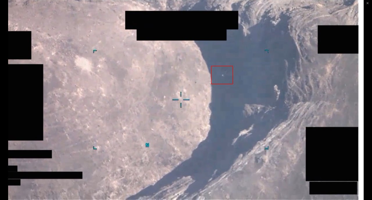
The Pentagon’s official description for all four is boilerplate: “likely derived from a full-motion video camera and an infrared sensor aboard a U.S. military platform operating within the United States Central Command area of responsibility.” The callsign is redacted. The exact unit is redacted. The mission is redacted. What remains is four minutes at a time of something small, bright on infrared, moving with purpose across the desert, and then gone.
The Four Videos
DOW-UAP-PR060: “Spherical UAP [CALLSIGN] 2021/04/12 obj 2”
DVIDS ID: 1007734 | WAR.GOV
This is the so-called “second object” captured during the mission. The IR footage shows a small, bright point moving steadily across rugged terrain. The object maintains altitude and heading for extended periods, occasionally shifting direction. At no point does it display the tumbling, fluttering, or erratic behavior typical of lightweight debris.
DOW-UAP-PR061: “Spherical UAP [CALLSIGN] 2021/04/12 vid 0”
DVIDS ID: 1007735 | WAR.GOV
This is the clip that got people’s attention. Around the 3:48 mark, a small bright feature appears and moves across a series of tightly packed terrain features. It travels for roughly two minutes across open ground before approaching a large rock formation and vanishing into what appears to be a cave entrance. The object’s movement is deliberate and consistent. This is the “4:00 moment” that triggered the underground base hypothesis.
DOW-UAP-PR062: “Spherical UAP [CALLSIGN] 2021/04/12 vid 1”
DVIDS ID: 1007739 | WAR.GOV
A continuation of the surveillance. The camera remains trained on the same terrain, and another bright object appears. The operator clearly found this location interesting enough to keep filming.
DOW-UAP-PR063: “Spherical UAP [CALLSIGN] 2021/04/12 vid 2”
DVIDS ID: 1007740 | WAR.GOV
The fourth clip from the same mission. Same location, same type of object, same sustained interest from the drone operator. Four separate recordings of the same patch of desert on the same day.
The Location: Geolocated
Within days of the release, the open-source intelligence community on Metabunk had geolocated all four videos to the same coordinates: 35.058833, 43.587951.
This places the footage in Salahaddin Governorate, Iraq, roughly 50 kilometers north of Tikrit. The terrain is classic north-central Iraqi high desert: deeply incised wadis (dry riverbeds) cutting through layered sedimentary rock, with steep gorge walls, undercut banks, and natural rock overhangs throughout. On satellite imagery, the landscape looks like a miniature Grand Canyon system, carved not by a mighty river but by millennia of flash floods.
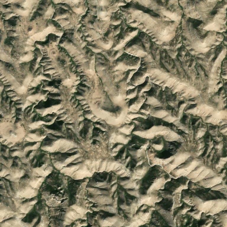
The “cave” visible in the IR footage is almost certainly one of these natural erosion features. A rock overhang or undercut gorge wall, viewed from directly above by a drone’s infrared camera at several thousand feet of altitude, is indistinguishable from a cave entrance. There is no depth perception in a top-down thermal image. A shadow beneath a two-meter overhang looks identical to a tunnel mouth.
That said, the terrain is also consistent with a region that has seen extensive military use. Iraq’s wadis have served as natural concealment for arms caches, insurgent positions, and smuggling routes for decades. If something unusual was happening at this location, it was happening in terrain that already invites human exploitation.
The “Plastic Bag” Theory
The dominant skeptical explanation for these objects is that they are plastic bags or lightweight debris caught in wind currents. This theory has merit. Iraq has a debris problem, and thermal imaging picks up plastic bags as bright, high-contrast objects against cooler ground. The objects in PR060-PR063 are small and their specific shape is difficult to resolve on degraded, publicly released footage.
But the plastic bag theory has problems when you watch all four videos in sequence:
- Duration. These objects are tracked for minutes at a time, covering significant distances. A plastic bag caught in thermal uplift might stay airborne for 30 seconds. Maintaining steady altitude and heading for two-plus minutes is not consistent with passive debris.
- Direction changes. The objects change heading in ways that suggest deliberate course corrections, not wind gusts. Wind-driven debris tumbles and drifts; it does not make sustained horizontal runs followed by sharp, banking turns.
- Multiple objects, same behavior. The fact that four separate objects were captured at the same location on the same day, all exhibiting similar flight characteristics, strains the coincidence threshold. Either this particular wadi was a plastic bag superhighway, or something else was happening.
- The operators kept filming. Reaper drone operators are trained professionals with limited loiter time and mission objectives. They do not spend their surveillance budget on garbage. Four separate video recordings from the same mission at the same location means the operator flagged this as anomalous and worth documenting. The AARO reviewer agreed enough to include it in a collection of 51 “potentially UAP-related records.”
What Makes These Videos Unusual
The PR060-PR063 set is remarkable for what it reveals about the scope of the UAP problem, even in the absence of definitive identification:
First, there is the operator behavior. The drone operator found something at this location worth recording four separate times. That is not how you treat known clutter. That is how you treat something you cannot immediately classify.
Second, there is the “into the cave” moment. Regardless of what the object is, the footage shows something entering a terrain feature and not emerging. If it is debris, it got snagged on a rock face. If it is something else, it found a hole and used it. Either way, the event was unusual enough that the operator kept the camera running.
Third, there is the chain of custody gap. AARO’s own description notes that “many of these materials lack a substantiated chain-of-custody.” The videos were uploaded to a classified network in June 2024, over three years after they were captured. We do not know who uploaded them, why, or what analysis (if any) was performed in the interim. This gap cuts both ways: it means we cannot confirm the objects are anomalous, but it also means AARO cannot confidently dismiss them as prosaic.
Fourth, there is the pattern. These four videos are part of a larger cluster of CENTCOM-area UAP recordings showing spherical objects over desert terrain. The Mosul Sphere (PR038), the Syrian instant acceleration object (PR051), the spherical UAP over Afghanistan (PR055), and now PR060-PR063 all share a family resemblance: small, bright on infrared, spherical or near-spherical, and captured by military platforms in the Middle East between 2019 and 2022. Either the CENTCOM area of responsibility has an extraordinary plastic bag problem, or something systematic is happening in that airspace.
What Was Happening in Salahaddin in April 2021
The geolocation places these videos not in some random stretch of empty desert, but in one of the most contested provinces in Iraq. Salahaddin Governorate was the heartland of the Sunni insurgency, Saddam Hussein’s home territory, and a critical corridor linking ISIS strongholds in Anbar, Kirkuk, and Diyala. By April 2021, the ISIS territorial caliphate had been dead for two years, but the group’s insurgent campaign was very much alive.
According to the U.S. State Department’s Country Reports on Terrorism 2021, “ISIS sought to reestablish footholds in Anbar, Diyala, Kirkuk, Ninewa, and Salah al-Din provinces, especially in the gaps between those areas frequently patrolled by the Peshmerga and ISF.” The EU Agency for Asylum noted that Salahaddin “appeared to be a major target during ISIL’s 2021 summer offensive.”
Critically, the Combating Terrorism Center at West Point published a detailed study in March 2022 titled “From Caliphate to Caves: The Islamic State’s Asymmetric War in Northern Iraq,” documenting how ISIS had constructed extensive cave and tunnel complexes in the Hamrin mountain region and throughout Salahaddin well before the collapse of the caliphate. These were not natural formations. They were engineered hideouts, weapons caches, and transit corridors built into the same kind of wadi systems visible in the PR060-PR063 videos.
The U.S. Department of Defense itself described the situation bluntly in 2018: ISIS remnants were “hiding in caves, deep wadis and tunnels in the desert and hills of western Iraq’s austere terrain.” In June 2020, Coalition aircraft destroyed three ISIS camps in Wadi al-Shai, a rural area in Kirkuk Province and a known hiding place for insurgents. In November 2020, Iraqi forces clearing the Makhoul mountain range in Salahaddin found five tunnels and military equipment. The pattern is clear: the wadis and cave systems of north-central Iraq were active battlegrounds in the counter-ISIS campaign throughout 2020 and 2021.
This context does not identify the objects in the videos. But it does explain why a Reaper drone would be loitering over that specific patch of desert at that specific time. The drone was almost certainly conducting intelligence, surveillance, and reconnaissance (ISR) in support of Operation Inherent Resolve, the U.S.-led counter-ISIS mission. The area north of Tikrit was prime ISIS insurgent territory. The wadis and rock formations were known to conceal tunnel entrances, weapons caches, and fighter movement routes.
Which makes the central question even more interesting: if the drone was watching for ISIS fighters moving through wadis and caves, what did the operator actually see? The objects in the footage are small, bright on infrared, and moving through terrain where insurgents were known to operate. Were they debris that happened to float through a militarily significant area? Were they something the operator initially flagged as a possible threat before ruling it out? Or were they something genuinely anomalous that coincidentally appeared in a location already under surveillance for other reasons?
We do not know, because AARO has not said.
The Underground Base Hypothesis
The most speculative interpretation of these videos is that the “cave” is not a natural formation at all, or that a natural formation is being used as an access point for something underground. This is the interpretation that captured public attention when the videos were released.
The evidence for this is thin but not zero:
- The object in PR061 appears to fly into the formation, not crash into it or get blown against it. The approach is controlled and the entry is clean.
- The location is remote and the terrain is complex enough to conceal ground-level activity from casual observation.
- The sustained operator interest suggests something more than routine clutter rejection.
The evidence against is substantial:
- Satellite imagery shows natural erosion features at the exact coordinates, including overhangs and undercut gorge walls that perfectly match the “cave” appearance on IR.
- No corroborating ground reports, signals intelligence, or follow-up investigations have been released.
- The objects are small enough that debris remains the most parsimonious explanation for each individual clip.
On balance, the underground base hypothesis requires assuming facts not in evidence. But the question it raises, why were trained military drone operators spending their mission time tracking objects into rock formations in the Iraqi desert, is worth asking regardless of the answer.
What We Still Don’t Know
The redactions in PR060-PR063 are extensive. We do not know:
- Which unit operated the drone platform.
- What the mission objective was.
- Whether the objects were detected by any other sensors (radar, SIGINT, visual).
- Whether follow-up investigation of the location was conducted.
- What the original uploader’s assessment was.
- Whether any of the four objects were ever identified to AARO’s satisfaction.
The PURSUE program promises transparency, and in releasing these videos the Department of War has delivered more than any previous administration. But transparency without context is just noise. Four videos of something flying into a rock formation in Iraq, stripped of their operational context and dumped into a public portal, does not constitute disclosure. It constitutes a data dump.
The real question is not what flew into that cave. The real question is what happened next. And on that, the Pentagon is silent.
Sources
- DOW-UAP-PR060 – DVIDS
- DOW-UAP-PR061 – DVIDS
- DOW-UAP-PR062 – DVIDS
- DOW-UAP-PR063 – DVIDS
- Metabunk geolocation thread
- Location on Google Maps (35.058833, 43.587951)
- PURSUE portal – WAR.GOV/UFO
- DoW Release 02 announcement
- Country Reports on Terrorism 2021: Iraq – U.S. Department of State
- “From Caliphate to Caves” – Combating Terrorism Center at West Point (March 2022)
- Coalition destroys ISIS camps in Wadi al-Shai – CENTCOM (June 2020)
- “ISIS Forces Degraded From Caliphate to Caves” – Department of Defense (December 2018)
Leave a Reply